Is homogenisation of Australian temperature data any good?
Dr Bill Johnston[1]
The ACORN-SAT project is deeply flawed, unscientific and should be abandoned.
Read on …
Situated 500 km east from Shark Bay, south of the Gibson Desert and adjacent to the Great Victoria Desert, Meekatharra is a hot, dry isolated outback town in mid-west Western Australia. Famously referred to as the end of the earth by Australia’s former Prime Minister, Malcolm Fraser when his aircraft was diverted from Perth in 1977 due to inclement weather, Meekatharra is now the epicentre of a mining boom and the airport serves as a hub for fly-in fly-out workers and a base for the Royal Flying Doctor Service (RFDS).
Constructed as an all-weather ‘bare-base’ aerodrome with long, sealed runways in 1943, linking Perth, the secret bomber base at Corunna Downs near Marble Bar, and Darwin, Meekatharra was one of only a few aerodromes in outback WA capable of handling heavy bombers. It was relinquished by the RAAF to the Department of Civil Aviation as a Commonwealth airport after 1946, and ownership transferred to the Shire of Meekatharra in 1993.
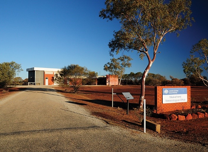
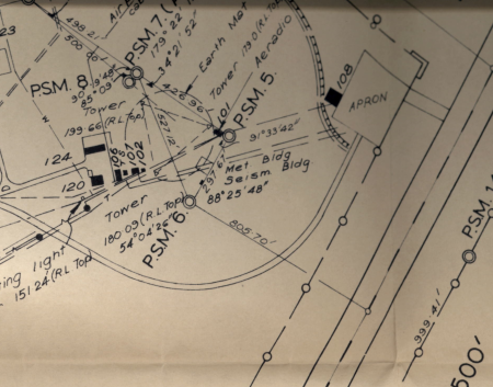
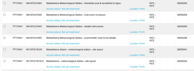
Weather observations commenced at the post office on the corner of Main and High streets Meekatharra in January 1926, having previously been reported from Peak Hill, about 110 km to the NW from 1898. Observations transferred to the former RAAF Aeradio office in 1950, and according to ACORN-SAT metadata, the site moved to a new meteorological office (MO) in about 1975 (Figure 1). However, files held by the National Archives of Australia (NAA) show that before the office was built in 1974, an instrument enclosure, instruments, a theodolite post and wind shield used in launching weather balloons were installed near the proposed new office in 1972 (Figure 2). The overlap with data from the previous Aeradio site, which continued to be used at least until staff relocated, probably in 1975 (Figure 3), was apparently used to smooth the transition to the new site.
ACORN-SAT
Meekatharra is one of 112 Australian Climate Observations Reference Network – Surface Air Temperature (ACORN-SAT) sites used by the Bureau of Meteorology, CSIRO, state governments, WWF and the Climate Council, to convince themselves, kiddies for climate action, and everyone else that the climate is warming irrevocably due to CO2.
Combined with dodgy measurement practices, data homogenisation is used at Meekatharra to create warming in maximum temperature (Tmax) data that is unrelated to the climate. Adjusting for a change in 1934 that was not significant, ignoring that the Aeradio site was watered, and that a period of overlap from 1972 was used to smooth the move to the MO site, allegedly in about 1975, for which no adjustment was made, created trends in homogenised data that were unrelated to the climate. Furthermore, data for the total of 18 sites used to homogenise Meekatharra Tmax, were not homogeneous.
The assertion that ACORN-SAT sites have been carefully and thoroughly researched, and that comparator reference sites selected on the basis of inter-site correlations would be broadly homogeneous around the time site changes occurred is demonstrably untrue. From multiple perspectives, the underlying proposition that series derived from up to 10 reference stations could provide a “high level of robustness against undetected inhomogeneities” is not supported.
As no change in the climate is detectable across the nineteen datasets examined, including Meekatharra, and the methodology is unscientific and deeply flawed, the ACORN-SAT project should be abandoned.

Figure 1. The Meekatharra meteorological office in August 2010 (from the ACORN-SAT Catalogue).
Figure 2. A screenshot of files held by the National Archives of Australia relating to the new 1972 instrument enclosure at Meekatharra (Search term Meekatharra meteorological).

Figure 3. Building plan in 1971 showing the RFDS hanger (108), Aeradio and met-office (101), the fenced enclosure southwest of the office including met (H2) and seismograph huts, towers suspending the aerial array and earth-mat, workshop (102), fuel bowser (107), power plant (106), and workshop and equipment buildings (120 and 124).

An important link – find out more
The page you have just read is the basic cover story for the full paper. If you are stimulated to find out more, please link through to the full paper – a scientific Report in downloadable pdf format. This Report contains far more detail including photographs, diagrams, graphs and data and will make compelling reading for those truly interested in the issue.
Click here to download the full paper with photos graphs and data.
Note: Line numbers are provided in the linked Report for the convenience of fact checkers and others wishing to provide comment. If these comments are of a highly technical nature, relating to precise Bomwatch protocols and statistical procedures, it is requested that you email Dr Bill Johnston directly at scientist@bomwatch.com.au referring to the line number relevant to your comment.
[1] Former NSW Department of Natural Resources research scientist and weather observer.